An oasis in the desert
Lyman Lake State Park in Arizona is full of pleasant surprises


In planning our trip from southwestern Idaho to central Texas, we were surprised to discover that our RV campground directories did not show any RV parks between Moab, Utah, and St. John, Arizona—a distance of about 560 kilometres (350 miles). That being the case, we decided to set the alarm for 5 a.m. and attempt to pull out by 6:30 a.m. This would allow us to avoid driving in the hottest part of the day. Our intended destination was Lyman Lake State Park, 16 kilometres (10 miles) south of the town of St. John, Arizona.
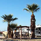
We pulled into the park in mid-afternoon and were pleasantly surprised to see a well-signed entrance with a space for large RVs to pull up near the registration office. The park offers beach sites, pull-throughs and back-ins on higher ground. They also rent cabins and yurts. We selected a back-in site that was very easy to get into, with water and electricity and a view of the lake. We had a brick pavilion, with a metal table that seated six. There were three electrical outlets and lighting also. Just outside was a barbecue and a fire ring. As nice as this reads, the actual site is better. All of the park roads were paved, as were the RV pads. There were no obstacles along the pad (giant rocks, overhanging tree limbs, etc.), so backing in was easy. Our site was on a curve, the road drifted upward and we just rolled down. The pad itself was level. What a nice experience so far.
When Tony started to hook up he discovered that we had an electrical box with 20, 30 and 50 amps and a water spigot that was high enough to make connecting our short hose easy and yet far enough away from the electrical box to avoid any potential safety hazard. Fully connected, we sat outside and watched the jet skiers enjoy the water with enough distance from any noise.
A scenic spot
Lyman Lake lies in the northeastern part of Arizona, not too far from New Mexico at an elevation of 1,828 metres (6,000 feet). It was created to act as an irrigation reservoir by damming the Little Colorado River, and is 1,500 acres in size. The lake is large enough to allow unrestricted water sports, swimming, boating, water skiing, jet skis, rafts and canoes. There is also a no-wake zone so fishermen can attempt to catch walleye, channel catfish and largemouth bass. It is fed by snow melt from Mount Baldy and Escudilla Mountain, which are the second and third highest mountains in Arizona.
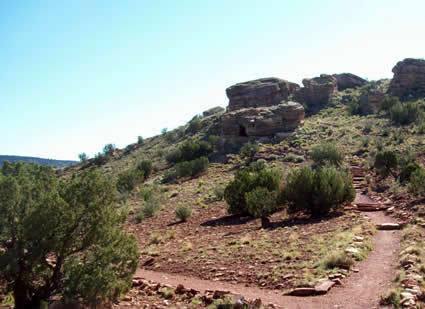
This park has much more to offer than the water. Like much of Arizona, this area was home to many different people over the centuries. Hence, petroglyphs can be found in a number of locations on three different trails within the State Park: Rattlesnake Point Pueblo, Peninsula Petroglyph and Ultimate Petroglyph Trails. Rattlesnake Point Pueblo is accessible by guided tour on weekends only. Ultimate Petroglyph is strenuous and can only be reached by boat. Peninsula Petroglyph trail is directly across from the RV site we were in and an easier walk up a path with petroglyphs that are within inches of the hiker and very well defined.
Easy trails and clear water
Obviously, Peninsula Petroglyph was the trail we were meant to explore (a good thing as Marguerite’s body could no longer be described as superwoman’s). It had been very hot so we waited until the early morning to start the hike. Walking was easy but as the trail rose Marguerite began to flag. Whoever created the trail did so with great care and sensitivity. Native stone lines the path and wherever it crosses a waterbed, a large flat stone creates the culvert. The earth is red, there are bushes of green and grey and then there is the blue lake.
We met another couple on the path and they described the top of the peninsula as giving views of the water clear enough to see fish swimming in its depths. They also told us of a tunnel in the rock. We wanted to investigate so we took that way before seeing the petroglyphs. It got hotter and we got a little winded but we could see the crevasse just ahead. We sat on a flat rock outside the opening—a great feat of courage as there are many rattlesnakes in this area and Marguerite was sure that one was coming "NOW!" The opening would allow someone without a backpack to pass through. The view from up there was breathtaking. Upon our descent, we met Jack Stewart, the new park ranger, who has ideas on how to improve the park. Not sure if one can improve on perfection, for we thought Lyman Lake State Park was one of the best we have been to. So, what started as “we will have to stop here because it is the only place around,” became “let’s stay another day and enjoy,” which is exactly what we did.
Lyman Lake State Park is located just off of US Hwy. 191 South, about 16 kilometres (10 miles) below St. John, Arizona. Phone: 928-337-4441.