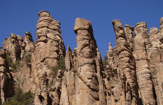
See the beautiful Standing Up Rocks in Arizona’s Chiricahua Mountains
Chiricahua National Monument


Want to see something unique, isolated, beautiful, historic and not the typical Arizona tourist destination? Then venture into the Chiricahua Mountains of southeastern Arizona. Take Interstate 10 east from Tucson and be sure to stop at the Texas Canyon Rest Area. The rock formations are a good indication of what is to come. At Willcox turn south on Highway 186 for 38 miles (62 km). Along this highway are desolate grasslands, occasional ranches, rolling hills and the transition into mountain vegetation. Your destination is the Land of Standing Up Rock.
Before you reach this national monument, take a little side trip to Fort Bowie Historic Site. There is little left of the old fort and it does require a short hike. This cavalry fort existed from 1862 to 1894 to guard the Apache Pass, the water supply, the Butterfield stage coach route and, most importantly, fight the Apache Wars against Cochise and Geronimo.
Chiricahua National Monument
You enter the Chiricahua National Monument park at Bonita Creek and travel an eight-mile (13 km) scenic canyon road through sycamore, oak and pine trees. Along this twisting paved road are scenic viewpoints such as Organ Pipe, Totem Pole, Sea Captain, China Boy and many others. The road ends at Massai Point, an observation point at 6,870 feet (2,094 metres). Massai was an Indian warrior who fought and surrendered with Geronimo but later escaped and was never recaptured.
From the viewpoint, Sulphur Springs and San Simon valleys stretch before you, but it is the forest of balancing pinnacles and columns of towering rocks that draws your attention. To me the rocks resemble soldiers standing at attention guarding the mountain. From Massai Point there are 13 major hiking trails such as Echo Canyon and Mushroom Rock Trails.
History of the Standing Up Rocks
These rock formations appeared 27 million years ago as volcanic ash melted into layers of rhyolite. As the mountains folded and faulted, the rhyolite cracked and softer rock was washed away, leaving the Standing Up Rocks. It was the Apache people who first named the rocks.
These mountains historically were the territory of the Chiricahua Apache. The Apache under Cochise resisted the arrival of the white man in the 1860s and 70s and were responsible for numerous massacres. Geronimo passed through these mountains in the 1880s before his surrender in 1886 at Skeleton Canyon, Arizona, just southwest of Rodeo, New Mexico.
When the Apache Wars ended, Swedish immigrants Emma and Neil Erickson settled here in 1888. Their daughter Lillian and her husband Ed Riggs developed the Faraway Ranch and were instrumental in having the Standing Up Rocks designated a national monument in 1924. During the Great Depression the Civilian Conservation Corps, part of Roosevelt’s New Deal, developed the park roads, buildings and hiking trails.
Nearby attractions
Plan on spending the entire day in this area. Once you have explored the Chiricahua Mountains, either return to Willcox, where there are museums featuring country singers/actors Rex Allen and Marty Robbins as well as the Chiricahua Regional Museum.
Another option is to take Highway 181 and stop at Cochise Stronghold west of Arizona Sun Sites. It was here in the Dragoon Mountains, a natural fortress of granite rock and cliffs, where Cochise lived and staged his attacks on the newly-arrived settlers and miners. Cochise is buried somewhere in these mountains.
Lastly, stop at The Thing service station/native gift shop on Interstate 10 and discover what The Thing is.